Summary
The assessment of costs and benefits plays an important role during decision making concerning the implementation of geographical information systems (GIS). This paper describes different categories of benefits which can be accrued by introducing geographic information systems: efficiency benefits, operational, strategic, and external benefits. Often, only some of these benefits are introduced into a cost-benefit ratio, and not all likely benefits are recognized by potential GIS users. In this paper a methodology of assessing benefits is applied to all categories of benefits in order to assign monetary values to different information products. The results can be introduced in a cost benefit model.
1 Introduction
The traditional methods of acquiring, storing, and analyzing spatial referenced data have a long tradition in public agencies and private companies and is of great importance for everyday work. However, there are some significant disadvantages caused my manual data acquisition and update (Guptill 1989):
The implementation of GIS in order to overcome those problems raises generally significant capital investments and continued expenses for data conversion, software, hardware, and education. The determination of benefits and costs of system implementation is substantial for potential users.
The scope of this paper is a classification of benefits. A methodology of assessing benefits is applied to all categories in order to assign monetary values to different information products.
2 Categories of Benefits
Several authors described classification schemes for GIS benefits. Born (1992) differentiates primary and secondary benefits, Knepper (1990) tangible and intangible benefits, Prisley (1987) and Clarke (1991) efficiency, effectiveness and intangible benefits, Antenucci (1991:67) Type 1 to Type 5 benefits. A main emphasis on external benefit can be found by Smith (1992).
In the following, a classification based on four benefit categories is used (Behr 1994):
2.1 Benefits due to increased efficiency
Benefits due to increased efficiency are considered the easiest to quantify (Prisley 1987) and can be achieved by enhancement of productivity (Antenucci 1991). An enhanced productivity can be achieved during GIS implementation in different ways:
2.2 Operational Benefits
Operational benefits correspond with capacity enhancements by higher human or technical ressources. Aspects of operational benefits are to a great extent independent of the selected system. Possible operational benefits are:
Ģ Enhancements to data quality (completeness, positional and attribute accuracy); higher degree of actuality;. The data quality is enhanced by applying system internal checks to data conversion and update (topological consistency, correctness and completeness of attributes).
Ģ User friendliness: Accelerated provision of information; generation of different thematic maps, flexible selection of area and scale; faster compilation of technical reports, statistical and logical evaluation based on data selection and combination of descriptive data, tabular data and spatial data; descriptive data are visualized on the bases of spatial phenomena; information in the right form, in a timely fashion;
Ģ Different departments will access and use the same geographic database;
Ģ Unification of graphical presentation corresponding to official cartographic standards;
Ģ High level of public service;
Ģ Integration of technical calculations for project engineering and operation; net simulation and tracing, net inventory: Evaluation of age and damages supports scheduling maintenance and repairs for technical infrastructure as road and sewerage network. Maintenance requirements can be prioritized, predictive methodologies can be applied for multi-year repair or investment plans (Dahlgren 1994). The availability of an engineering information base will allow engineers to conduct strategic planning studies by identifying the under-utilized parts of a network (Eaton 1994).
2.3 Strategic Benefits
Apart from the above mentioned benefit catagories which are quite easily to quantify, strategic aspects of GIS must also be taken into consideration. Grimshaw (1994) emphasizes this role of spatial information processing.
Strategic benefits are highly correlated with the strategic goals of the organisation. Strategic goals can be reached by integrating spatial information processing into the general business processes of the organisation. Strategic benefits can be reached by:
Ģ Realization of technological changes (e.g. decentralization of electronic data processing);
Ģ Establishing a corporate technical information processing by building up a corporate database;
Ģ Optimization of business processes (lean decision structures, support of technical maintenance);
Ģ Better motivation of employees by providing an identification object and better job satisfication;
Ģ Gain of competitive advantages;
Ģ Increased orientation to the customer's needs and improved public image through modern information managementment of public relations.
Ģ Compliance with laws, regulations, and standards (protection of the environment, support of ecological applications).
Ģ Enhancements to decision-making processes through reduction of uncertainty. Decisions can be made with more confidence and conviction based on more and better information.
2.4 External Benefits
A benefit analysis must consider all kinds of benefits wether they are accrued by the implementing organisation itself or by potential additional users of the GIS products provided. Particularly in public agencies external benefits have to be taken more closely into consideration (Gramlich 1981, cit. by Wilcox 1990): The government has a responsibility to consider more than the monetary cost and benefits of a decision. It has to fullfill the desires of the public in its entirety. The cost-benefit analysis must reflect the social benefits and costs and the impacts on other governmental programmes and policy goals.
External benefits can by achieved
Ģ for municipal departments which are not directly integrated in the implementation process,
Ģ for citizens, accrueing benefits from new, enhanced or more quickly produced services (accelerated provision of building permits, enhanced environmental protection, improved safety management, improved decision making in policy, accelerated trouble call analysis).
Ģ for private organisations, as civil engineering companies, planers, architects, which obtain more and better information,
Ģ for other public organisations (communities, counties, government) by easier access to information and faster data distribution.
The difficulty in the case of public GIS applications is that there are no market prices for a lot of services provided. Hence, the benefit of GIS based services must be estimated during the survey. However, it is essential for external benefits that they exist if people who benefit in this way pay for these benefits or not (Smith 1992).
3 Quantifying the Benefits
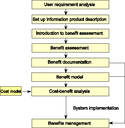
In the following the activities for the benefit assessment are described (see figure). Prerequisite for benefit assessment and cost-benefit analysis is the performance of an in-depth requirement analysis in all departments concerned by the GIS implementation.
One part of the requirement analysis document describes the information requirements. The GIS being introduced must fullfill these requirements by providing corresponding information products (maps at different scales containing different data sets, reports, charts, etc.). These digitally generated products can replace conventional products or can be new products which can be produced only by GIS functionalities.
The detailed description of the information products provides the basis for the benefits assessment (Smith 1992). The description gives details about information content, scale, significance for business purposes, legal background, technical standards, responsibilities, and includes a brief sample of the information product. The form of the description must be well suited to give a good understanding for product specific features, usabilities, and objectives. This can be done in tabular or narrative form.
During a project meeting, the benefit categories and the structure of the benefit assessment are explained to the potential users. The objectives of this presentation are the participation and the motivation of all persons involved. They are qualified
Ģ to recognize the importance of the information products for their daily work,
Ģ to identify, quantify and verify benefits,
Ģ to perform the survey largely independently.
For each information product, each type of benefit must be estimated separately directly in monetary values or ¢ if not possible ¢ in terms of reduced staff time. The estimation must be performed with regard to actual and future task. It must be documented for what purpose the information product is used.
The benefit estimation is done independendly by the departments involved. In some cases, help must be provided by a consultant, because during this project stage, the limited knowledge about the possibilities of spatial information processing aggravates the benefit assessment.
During the evaluation of the results, a verification can be necessairy if estimations for the time needed for some tasks and for the frequency of some activities are too subjectivly.
The results of the survey are reported in a benefit assessment document. The aggregated data can be introduced into a cost-benefit analysis where they are compared to the estimated costs of system implementation (hardware, software, maintenance, training, data conversion, etc). The cost model used is not discussed further in this paper.
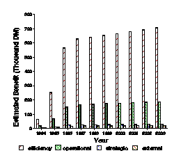
The results of a benefit assessment in a municipality with technical and planning departments is shown examplary in figure . The anticipated benefit is set to 100 percent for 1996 after finishing system implementation. A reduced benefit is expected in the years 1994- 1995 during data conversion process. A number of GIS users have experienced un-anticipated benefits from the use, combination, and analysis of their information products. They discover capabilites of the system which were originally not required. Hence, an increase in benefits of 2 percent per year is assumed in consultation with the GIS users.
In the results demonstrated here the benefits due to increased efficiency are predominant. In other cases, organisations can put emphasis on other benefit categories, e.g. the external use can predominate.
The benefit documentation forms the base of the benefits management process (Grimshaw 1994:127). The realization of the anticipated benefits needs managing like other tasks during GIS implementation and use. Benefits management includes the responsibility for realizing benefits and review performances.
4 Results
Applying the methodology described for assessing the benefits of GIS implementation it turns out:
Ģ The assumptions for the anticipated benefits are based on estimations of the departments involved in the GIS implemention. They are supported by the people involved who will be responsible for the achievement of these benefits.
Ģ The potential GIS users are able to identify and value different categories of benefits. The same goes also for strategic and external benefits which are often regarded as non-quantifiable.
Ģ There remain some benefits which are noted by city departments without assigning specific monetary values. The number of these non-quantified benefits must be minimized.
The results of a benefit analysis have to be regarded to be more conservative
Ģ if the possibilities of a GIS are not adequate known in order to identify all potential kinds of benefits;
Ģ if some strategic and external benefits are not completely recorded with monetary values,
Ģ if the interdepartmental support is considered too low or insignificant,
Ģ if the lack of actuality of some data sets is only insufficiently taken ino account.
The result of the cost-benefit analysis is always connected with strategic aspects specific to the institutional context ¢ an analysis in the public sector will tend to be different from that undertaken in private or utility companies. Particularly in municipalities, there is a growing disparity between revenues and costs. On the other hand, an increasing demand for public services is raising. GIS can be a valuable tool by providing actual and complete information for daily work and decision making.
5 References
City of Grand Prairie, Alberta, Canada GIS Plan
Actual benefits realized through implementation of a GIS von Todd A. Pistorese
Quantifying GIS Benefits: A Bottom-Up Approach that Builds Management Confidence von Nancy B. Lerner
Kristine Kelly, Theresa Pardo, Sharon S. Dawes, Ann DiCaterino, and Winsome Hérard: Sharing the Costs, Sharing the Benefits: The NYS GIS Cooperative Project. CTG Final Project Report 95-4 [85 Pages],December 1995 [htmlabstract] [pdf document]
Antenucci, J. C., Brown, K., Croswell, P. L., Kevany, M. J., Archer, H., 1991: Geographic Information Systems: a guide to the technology. Van Nostrand Reinhold, New York, 301 S., ISBN 0-442-00756-6
Behr, F.-J., 1994: Erhebung von Nutzenaspekten bei der Einführung geographischer Informationssysteme. Geo-Informations-Systeme, Vol 7, No. 2, 1-8
Born, J., 1992: Ist die Einführung von GIS durch Kosten-/Nutzenanalyse entscheidbar? in: Proceedings AM/FM/GIS European Conference VIII, Montreux, 49 - 56
Clarke, A.L., 1991: GIS Specification, Evaluation, and Implementation. in: Maguire, D.J., Goodchild, M.F., Rhind, D.W. (Eds.): Geographical Information Systems: principles and applications. Longman, London, S. 477-488
Dahlgren, D.A., 1994: The role of GIS in public infrastructure management. Proc. AM/FM/GIS European Conference X, Heidelberg, 233/1 - 233/3
Eaton, A., 1994: Competing for markets and maximising investment returns. in: Proc. AM/FM/GIS European Conference X, Heidelberg, 111 - 115
Gramlich, E. M., 1981: Benefit-Cost Analysis of Government Programs. Prentice-Hall, Engelwood Cliffs, NY
Grimshaw, D. J., 1994: Bringing geographical information systems into business. Longman Group Limited, Harlow, 273 pp.
Guptill, S. C., 1989: Evaluating Geographic Information Systems Technology. Photogrammetric Engineering and Remote Sensing, 55, 1583 - 1587
Knepper, W., 1990: Allgemeiner Nutzen- und Kostenrahmen für Aufbau und Fortführung eines Netzinformationssystems mit Hilfe der GDV. Wasser - Abwasser gwf, 13 (1990) Nr. 7, 342 - 347
Prisley, S. P., 1987: Cost-Benefit Analysis for Geographic Information Systems. Proc. Second Annual International Conference, Exhibits and Workshops on Geographic Information Systems GIS '87. American Society for Photogrammetry and Remote Sensing, Falls Church, VA
Smith, D. A., Tomlinson, R. F., 1992: Assessing costs and benefits of geographical information systems: methodological and implementation issues. International Journal of Geographical Information Systems, Vol 6, No. 3, 247 - 256
Webb, R., 1994: Mobile GIS: an operational tool for utilitys. Proc. AM/FM/GIS European Conference X, Heidelberg, 270 - 274
Wilcox, D. L., 1990: Concerning 'The economic evaluation of implementing a GIS'. International Journal of Geographical Information Systems, Vol 4, No. 2, 203 - 210